In a couple of weeks (May 12th), international industry leaders and other 3D proponents and interested entities will meet in São Paulo, Brazil for what is being called the 'X3D Earth' initiative.
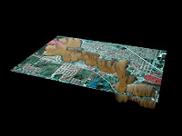
Web3d.org lists the purpose of the X3D Earth group as being: "to create an infrastructure of open and extensible standards to visualize in three dimension objects from real world and constructions of information in a geospatial referenced context." This infrastructure will presumably be based on X3D and has the somewhat lofty goal of compiling and archiving all available (public and government controlled) terrain, imagery, and cartography data.
While I'm all for the ideas behind this initiative (open and centralized access to spatial data), isn't this sort of re-inventing the wheel? I realize Google's data isn't exactly 'open and accessible,' but they seem to have had great success implementing an architecture that fits many of X3D Earth's goals and has been proven popular and successful with users. With Google Earth's large user base and ever-growing repository of geospatial referenced content, would a functional X3D Earth implementation be able to reach the critical mass of users needed to be successful?
Maybe someone over at Google will take notice - it would be great to see some sort of collaboration here. I think everyone would benefit from improved data access and standardization and we wouldn't have to watch the death of another well intentioned Web3D initiative!

No comments:
Post a Comment